Oceangoing Cargo Ships Safety & Operational Matters
Home || Tanker Safety || Container Ship Handling || Commercial Management || EMS ||

Procedure for ECDIS alarms - a brief guide to navigators at sea

Electronic chart display and information system (ECDIS) – This newly developed navigational tool using digital charts (vectorized and raster charts) for navigational duties usually carried out with paper charts. The equipment must be type-approved and uses up-to-date official charts. As long as the area covered by vector charts (ENC) is small, the ECDIS should be able to cover both vector and raster (RNC) charts. When operating in raster mode, an ECDIS must be used together with an appropriate folio of up-to-date paper charts.

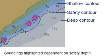
As per IMO performance standards, the ECDIS should include a function, where the user can select a safety contour from the depth contours available on the Electronic Navigation Chart (ENC).


containerships operational matters
Oil Tanker Safety Guide

ECDIS alarm parameters

Safety Contour: Is to be set to the maximum dynamic draft, plus 10% of static draft. Note that ECDIS will select the next deepest contour contained as an object within ENC. Therefore it may be necessary to cross the safety contour during transit. To ensure the mariner is fully aware of the depth of surrounding water the display must show spot soundings and isolated dangers. ‘No-go’ areas can also be displayed, using the ‘Add Info’ function.

ECDIS-alarm-parameters
ECDIS alarm parameters

Safety Depth: Is to be set to at least the maximum dynamic draft, plus 10% of static draft.

Shallow Contour: This may be set to the same value as the safety contour, or to a lower value, to allow a better graphical representation of the seabed gradient.

Deep Contour: Should be set to twice the static draft, to indicate the depth at which the onset of the squat may occur.

Height Alarm: Should be set to the final air draft, plus the minimum safe clearance

Cross Track Error: Set realistically for each leg of the voyage. Automatic route-checking only considers hazards within the XTE' tramlines'. For example: During port approach XTE may be width of buoyed channel, in open sea XTE may reflect Master’s CPA requirements.

ECDIS anti grounding alarms
Setting up anti grounding alarms on ECDIS

Anti Grounding Alarm

Guard Ring/Guard Zone/Anti Grounding Cone: i)Monitoring sector adjusted to suit prevailing situation;
ii)Any hazard entering sector will trigger alarm

Guard Vector: Vector length set appropriately to speed/proximity of hazards
Note: more than one grounding has occurred because vector length has been set to ZERO!

ECDIS vectors
Comparison of Vectors set on ECDIS

Vectors

Settings should be appropriate for the given situation and not cause excessive or unnecessary alarms. For example, the following vector lengths could all be considered reasonable:
  1. Deep sea passage – 15 minutes.
  2. Approach to fairway buoy – 3 minutes.
  3. Approach to berth – turned off.

Other Alerts

Waypoint Approach : Off-course : Set following Master's instructions
Note that the vessel may not pass through certain WP, but (especially in case of large turn) will calculate the turn based on predicted advance/transfer and therefore calculate appropriate w/o point.

Comparison of raster and vector coverage for the same area
Comparison of raster and vector
coverage for the same area

Failure to comply ECDIS - a case study : A 4,000 GT general cargo ship adjusted its ETA to arrive at the pilot station earlier than planned to meet a high tide. The vessel subsequently grounded on a sandbank.

The passage plan was amended when the ECDIS was displaying the ENC at a scale of 1:100,000. Visual inspection of the route on the ECDIS showed it to be clear at this scale. The fact that the vessel would pass a starboard hand lateral buoy on the port side while following the buoyage direction was not investigated further.

Had this been checked, it would have been evident that the amended passage plan took the vessel over a sandbank with charted depths considerably less than the vessel's draft. However, this was not obvious to the deck officer who amended the passage plan, or to the bridge officer on watch at the time of the grounding. The safety contour function on the vessel's ECDIS was fitted with a watch vector function whereby time and angle for the predicted movement of the vessel needed to be set to trigger the safety contour alarm.

Although the safety contour had been set at 30m, the alarm did not function as the watch vector had not been activated by the bridge team. It was found that the Master and deck officers had received no formal ECDIS training. They failed to recognize the significance of the safety contour and did not know how to set a watch vector ahead of the vessel. They were also unaware of the need to check the ECDIS for violations of user-defined limiting parameters (such as the safety contour) when adjusting the passage plan.

Drills and On-Board Practical Failures : Masters are to conduct a risk assessment and develop a Safety-Critical Operations Checklist for coping with ECDIS failures and operating in alternate modes.
Drills are to be conducted monthly by each watchkeeper, to ensure familiarity with procedures, and operation in secondary modes.

Main features of shipborne ECDIS

North up/heads capability of ECDIS: In the normal north up mode, the ship moves across the static chart until it approaches the edge of the screen when a new section of the chart is automatically displayed. In heads up, the vessel remains in the center of the display while the chart moves underneath. The vessel always appears up on display with the image automatically rotated to the correct orientation, thereby matching the scene outside the window.

Radar overlay – A navigation system which superimposes live radar video output over ECDIS. It provides a scan-converted output for display, automatically scaled to suit the displayed chart. The transparency can be adjusted so that the chart can be seen through the radar image. The overlay and its controls conform to the ECDIS standard for combining radar with the ECDIS chart display.

Electronic navigational chart (ENC), also vectorised chart – Vector charts made up of layers which can be displayed selectively. Each point on the chart is digitally mapped, allowing information to be used in a more particular way, such as clicking on a feature to display its information. Vector charts have the advantage of being "interactive." For instance, the operator can pre-set the vessel draught and a ˝ mile exclusion zone. When the vessel is within ˝ mile of an area of shallow water, an alarm activates. Chart data can be shared with other equipment such as ARPA and radar. There are various chart formats. Hydrographic offices are responsible for the production and accuracy of the ENC material.


Related Information

ECDIS warning procedure
Although many vessels have fitted Electronic Chart Display and Information Systems (ECDIS) on a voluntary basis, its use will significantly increase once passenger vessels, tankers and dry cargo ships begin to comply with mandatory SOLAS requirements for ECDIS.

ECDIS alarm parameters
Safety Contour: Is to be set to the maximum dynamic draft, plus 10% of static draft. Note that ECDIS will select the next deepest contour contained as an object within ENC....

Passage planning guideline on ECDIS
The principles of voyage planning are the same with ECDIS as with paper based navigation...

ECDIS warning procedure
Although many vessels have fitted Electronic Chart Display and Information Systems (ECDIS) on a voluntary basis, its use will significantly increase once passenger vessels, tankers and dry cargo ships begin to comply with mandatory SOLAS requirements for ECDIS.

Admiralty Chart correction procedure
There are currently two methods of carrying out electronic chart corrections, either via Weekly Updates, CD or downloaded weekly from a recognised electronic chart supplier’s data. The preferred method will be decided by the Management Office depending on the communications equipment onboard the vessel but in the majority of cases the lack of internet access will determine the update CD as the best option....

Requirement of ECDIS training and implementation guideline
To ensure compliance with the ECDIS requirement, to ensure that the transition is smooth, equipment installed and Master and Bridge watch keepers are all provided generic and ship-specific ECDIS equipment training before the implementation dates of various type vessel: .....

What are the safe navigational procedure for the officer of the watch ? ....
The officer of the watch (OOW) shall comply with masters standing orders (including any supplementary instructions) to carry out the navigational watch. He must always bear in mind that he is the Master’s representative and has primary responsibility at all times for the safe navigation of the ship and for fully complying with the latest COLREGS .....

Guidance on ECDIS- data presentation and performance check standards
Type approval is the certification process that ECDIS equipment must undergo before it can be considered as complying with the IMO Performance Standards for ECDIS. The process is conducted by type approval organisations and marine Classification Societies. ...

...


Other info pages !

Ships Charterparties Related terms & guideline
Stevedores injury How to prevent injury onboard
Environmental issues How to prevent marine pollution
Cargo & Ballast Handling Safety Guideline
Reefer cargo handling Troubleshoot and countermeasures
DG cargo handling Procedures & Guidelines
Safety in engine room Standard procedures
Questions from user and feedback Read our knowledgebase
Home page


ShipsBusiness.com is merely an informational site about various aspects of ships operation,maintenance procedure, prevention of pollution and many safety guideline. The procedures explained here are only indicative, not exhaustive in nature and one must always be guided by practices of good seamanship.

User feedback is important to update our database. For any comment or suggestions please Contact us
Site Use and Privacy - Read our privacy policy and site use information.
//Home //Terms and conditions of use

Copyright © 2015 www.shipsbusiness.com All rights reserved.